
The Yungas
Overview:
The Yungas, the second of the three major regions of Bolivia, is a humid subtropical region that forms a narrow strip between the Northern Andes and Chaco made up of sharply tilted mountains with an altitude between 490 meters and 2,750 meters. The Yungas (an Aymara word meaning “warm lands”) is divided into three zones. The highest of the zones, called ceja (eyebrow) is similar to the Altiplano, while the intermediate zone consists of fertile river valleys. The valleys and basins of the Valles regions are often treated as part of the Yungas and are broader and more densely populated. Rich with resources, settlers have been attracted to the Yungas by its surplus of gold, coca leaves, coffee, cacao, and a medley of other crops. Joining the Paraguay, Chaparé, Ichilo, and Río Grande to form the Mamoré, a tributary of the Amazon, the Pilcomayo River drains the Yungas and Valles regions flowing southward. In conclusion, the Yungas are a wet and forested belt of rugged mountain terrain.
Images:

The Pilcomayo River
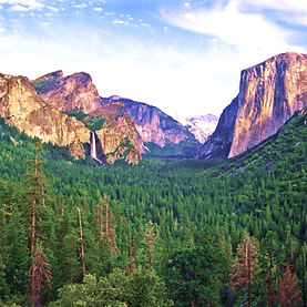
The Valles Region

North Yungas road
Works Cited:
"Death Road and Coca Leaves: Bikepacking the Yungas." Bikepacking.com, 13 June 2016, https://bikepacking.com/plog/bikepacking-yungas-bolivia/.
Kurian, George Thomas, ed. "Bolivia: Geographical Features." World Geography and Culture Online. Facts On File. fofweb.infobase.com/activelink2.asp?ItemID=WE39&Geography.aspx&iPin=M0020321&SingleRecord=True. 12 Feb. 2025.
Latin America and Caribbean Geographic, 21 April 2024, https://lacgeo.com/pilcomayo-river-south-america.
Stanković, Stanislav. "Death Road of Bolivia." Atlas Obscura, https://www.atlasobscura.com/places/north-yungas-road.
"Valles de Bolivia." Bolivia Best, https://boliviabest.com/naturaleza/bolivia-y-sus-tres-grandes-zonas/attachment/valles_bolivia/.
“Yungas | Andean, Tropical, Cloud Forest.” Britannica, https://www.britannica.com/place/Yungas. Accessed 12 February 2025.